9 Apr 2025
This new snapshot from the European Space Agency’s Mars Express deftly captures the two distinct faces of Mars: ridged and rugged versus smooth and unmarked.
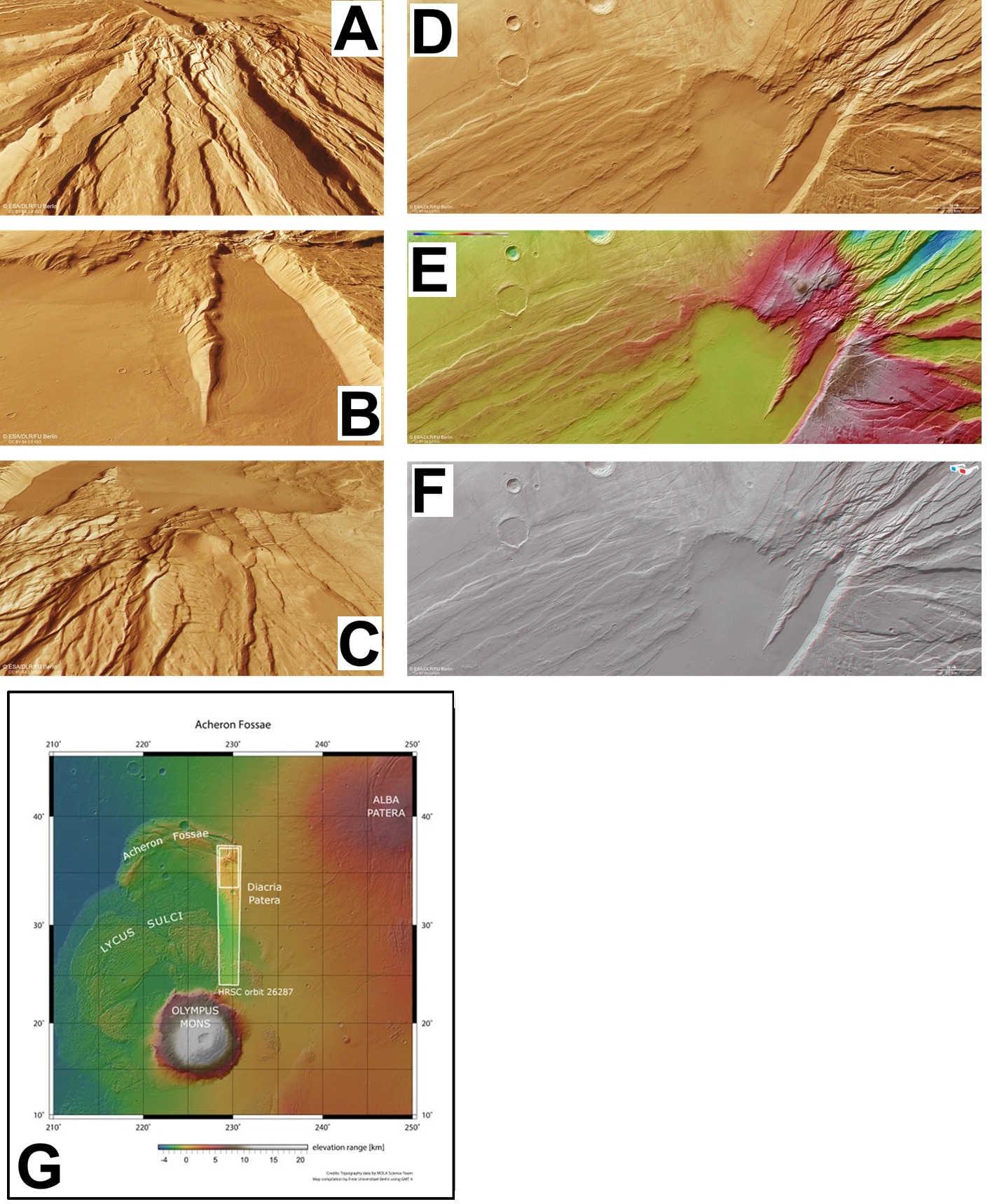
Mars is covered in amazingly diverse terrain. In fact, the planet is roughly divided in two; half of the globe is wrapped in ancient ground that’s peppered with craters and other signs of age and activity, while the other half is far smoother, having been resurfaced by lava over time.
Both types of terrain can be seen in this new snapshot from Mars Express’s High Resolution Stereo Camera (HRSC). Known as the Acheron Fossae region, this patch of the Red Planet lies relatively close to two huge volcanoes (both out of frame): Olympus Mons, found about 1200 km to the south (left), and Alba Mons, found a similar distance to the north-east (bottom right).
Together with the twisting tension caused by movements in the crust, these volcanoes shaped this region back when Mars was a far more active planet than we see today. The trough-like features covering the right third of the frame are known as ‘grabens’; they formed nearly four billion years ago as parallel blocks of crust were stretched and pulled apart. Long chunks faulted and fell away to cause ditches, leaving behind higher chunks in between. The ridges continue for around 800 km, equivalent to almost the length of Germany.
The smooth, unwrinkled patch at the lower centre of the image is the start of younger plains extending away from Acheron Fossae. Closer to the grabens, the plains are marked by signs of flowing rock glaciers (either shards of rock captured within flowing ice, an ice flow covered by rocky scree, or something in between). We can see where this flowing rock has moved away from the cliffs to form softly meandering lines, reminiscent of waves breaking on a beach, and culminated in build-ups of rock that gently slope away from the cliffs (‘debris aprons’).
The 3D perspective views below zoom in on some elements of the main image, including the signs of glacial flow, the grabens and where the grabens meet the smooth plain.
Further from the cliffs, the flat, smooth ground is likely to have formed as lava flowed out from Alba Mons, covering any existing features with a smooth blanket of fresh rock. This blanket also covered an old impact crater here, still visible as a half-arc at the centre of the frame (and measuring some 28 km across).
To the upper right, three features add to the geological intrigue of this graben system: a trio of conical peaks standing several kilometres tall, and thought to be volcanic.
The aforementioned grabens have cut through some of these domes, indicating that the crust here was fractured and deformed even after the domes were created.
ESA’s Mars Express has been capturing and exploring Mars’s many landscapes since it launched in 2003. The orbiter has mapped the planet’s surface at unprecedented resolution, in colour, and in three dimensions for over two decades now, returning insights that have drastically changed our understanding of our planetary neighbor.
[Image]
(A) Acheron Fossae in perspective (2)
(B) Acheron Fossae in perspective (1)
(C) Acheron Fossae in perspective (3)
(D) Acheron Fossae as seen by ESA’s Mars Express. Click on the image to zoom in and explore in more detail.
(E) Topography of Acheron Fossae – this colour-coded image shows the height of the land
(F) Acheron Fossae in 3D
(G) A broader view of Acheron Fossae