6 Oct 2020
Using the Isaac Newton Telescope (INT), a team led by University of Warwick astronomers has concluded that geosynchronous orbital debris posing a threat to operational satellites is not being monitored closely enough. In a new published survey they report that more than 75% of the geosynchronous orbital debris they detected could not be matched to known objects in public satellite catalogues.
The research forms part of DebrisWatch, an ongoing collaboration between the University of Warwick and the Defence Science and Technology Laboratory (UK) aiming to provide a fresh take on surveys of the geosynchronous region that have been conducted in the past. The research was part-funded by the Science and Technology Facilities Council (STFC), part of UK Research and Innovation, and was supported by the Royal Society.
The astronomers focused their survey on the geosynchronous region, located roughly 36,000 kilometres above the Equator, where satellites orbit with a period that matches the Earth's rotation. Far above the outermost layer of the Earth's atmosphere, there are no natural mechanisms (like atmospheric drag) to induce orbital decay, so debris generated in the vicinity of the geosynchronous region will remain there for a very long time indeed.
This survey was optimised to search for faint debris, objects that are too small or poorly reflective to be regularly monitored and recorded in publicly available catalogues. To uncover faint debris, the astronomers made use of the INT, allowing it to collect photons of light over a large area. They used an optimised strategy to ensure that the sunlight reflecting off of candidate objects would fall within the same pixels of the camera, to increase their chances of being detected. Strips of sky were scanned above, along and below the geostationary belt, where most of the operational geosynchronous satellites reside.
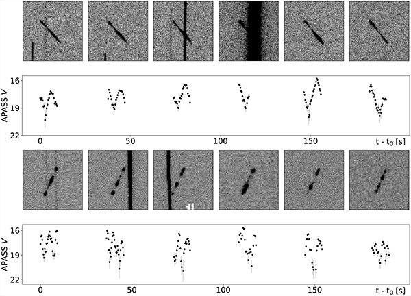
Images from the survey were analysed using a bespoke software pipeline designed to pick out candidate debris objects and investigate their brightness over time. The resulting 'light curves' contain a wealth of information about the objects themselves, including their shape, surface properties and attitude, but are also affected by other factors like viewing geometry and atmospheric interference. Disentangling these components remains a very difficult task, and large quantities of high-quality data will be key to developing and refining the necessary techniques.
Artificial debris orbiting the Earth can have a number of causes: the satellites themselves become debris when they reach the end of their mission lifetime; rocket bodies abandoned after successfully launching their payloads can explode or 'break-up' after many years in orbit; collisions can occur between orbiting bodies, sometimes resulting in thousands of new fragments; the harsh environment of space can deteriorate satellites over time, shedding bits of insulating blanket and paint flakes.
The astronomers are calling for more regular deep surveys of orbital debris at high altitudes to help characterise the resident objects and better determine the risks posed to the active satellites that we rely on for essential services, including communications, weather monitoring and navigation.
[Image]
Examples of light curves extracted from the survey images for faint debris tracks. Owing to the observational strategies employed, stars appear as near-vertical streaks in the image thumbnails, while the objects of interest manifest as short trails. A significant degree of brightness variation can be seen for both examples.