3 Jun 2022
Celebrated each year on 5 June, World Environment Day focuses on awareness of environmental challenges and action to protect planet Earth. Take a look at five ESA-supported projects that use satellite data and services to address specific environmental problems.
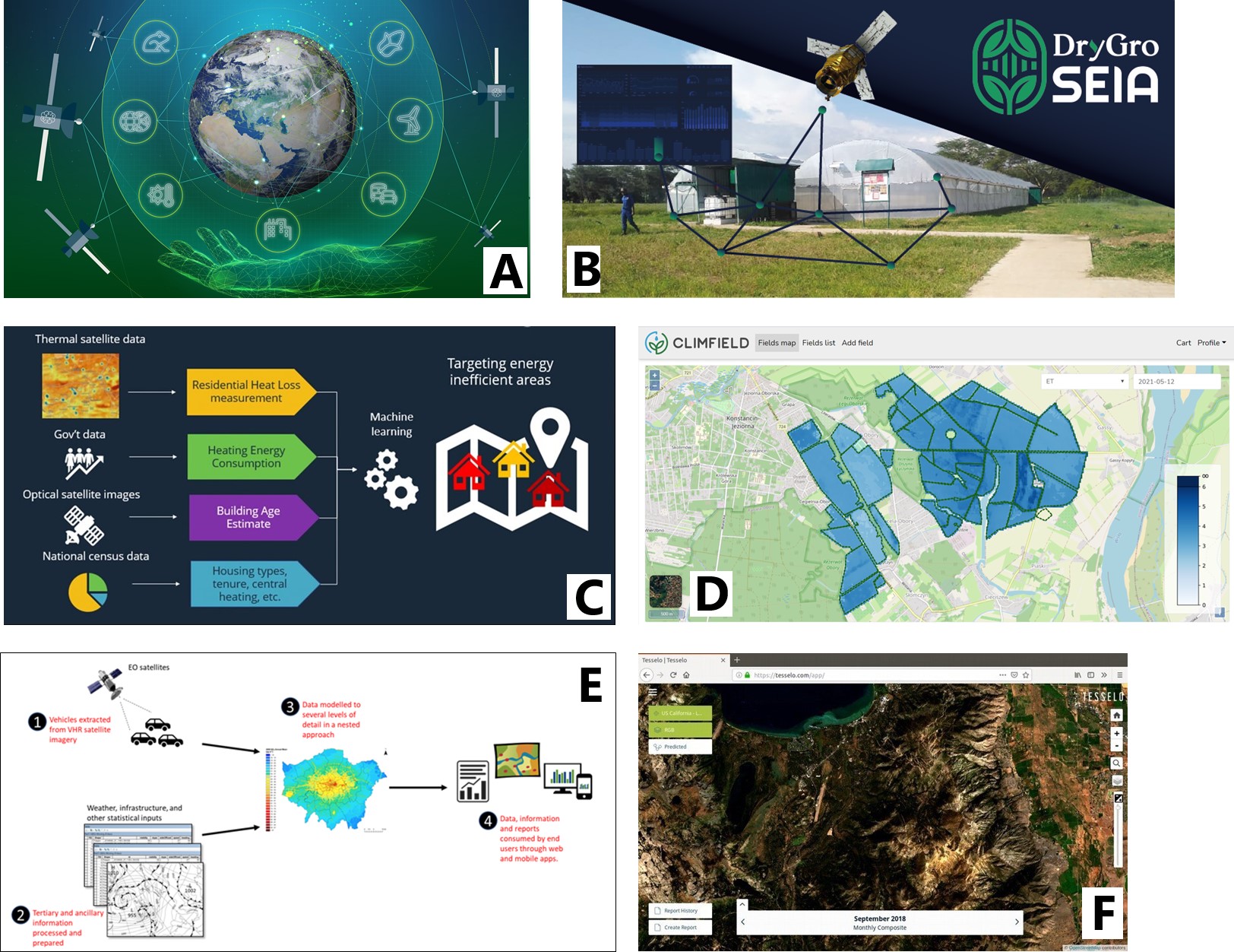
ESA is planning to boost the use of green technologies through its proposed space for a green future accelerator. This accelerator will provide European decision-makers, industry, and society with essential tools and solutions to support a sustainable green transition towards a carbon-neutral, resource-efficient and resilient society. It will also stimulate the development, deployment and use of advanced data, science, technology, applications and services for sustainable life on Earth.
The accelerator concept ('space for a green future' sits alongside 'rapid and resilient crisis response' and 'protection of space assets') was introduced in 2021, but building a more sustainable world has been a focus of the Agency since its creation in 1975. From an alternative to rainforest-destroying soy crops, to pinpointing where energy-efficiency measures are needed most, in this article, we present five recent projects supporting the shift to more sustainable lifestyles.
Intelligent agriculture for an alternative to soy
Problem: Soy is one of the world's top four-most produced crops, but an increase in land used for soy production is resulting in the destruction of forests, savannahs and grassland. The development of sustainable alternatives is vital for feeding future generations.
ESA-backed solution: With 80% of the world's soybean crop being used for animal feed, DryGo is a company that aims to produce a new inexpensive, high-protein animal feed input called lemna – using Earth observation satellite data and communications satellite services. Producing lemna uses 99% less water than producing soybeans, and the crop grows eight times faster.
With ESA's support, DryGro is developing six lemna growing units in Kenya to pilot the new technology. To mitigate many of the factors currently limiting agricultural productivity, DryGro uses climate management systems that rely on a steady stream of data. These data come from Earth observation satellites, ground sensors, and weather forecasts.
Pinpointing where energy-efficiency measures are needed most
Problem: In 2017, approximately 11% of households in England faced fuel poverty, and this percentage is set to increase dramatically with increasing fuel costs. Addressing this issue can be challenging, however, as at-risk households are not always easy to identify. Traditional energy efficiency monitoring programmes rely on door-knocking or bulk mailings to contact customers and identify their needs.
ESA-backed solution: Energy supplier E.ON has been working with ESA and Earth observation specialist Astrosat to develop ThermCERT, a thermal efficiency reporting tool to pinpoint where energy-efficiency measures are needed most across the UK. The system – which uses thermal and optical images from satellites – could turn out to be a game-changer for reducing energy costs and improving efficiency, especially when it comes to heat loss in vulnerable homes.
Enabling Polish farmers to irrigate efficiently
Problem: Often, rainfall is not enough for crop production, and we must bring in water artificially. Across Europe, the agricultural industry is using more and more water for irrigation. But with the climate changing and populations growing, we are seeing rainfall decreasing and production increasing in many regions. We need a solution to support farmers to irrigate their crops efficiently.
ESA-backed solution: A project supported by ESA Space Solutions called ClimField developed a service that uses Earth observation satellite data to help farmers make decisions related to irrigation and water management.
The project, which ran from February 2020 to November 2021, was carried out by WASAT, a Polish company aiming to provide geoinformation services and IT solutions based on satellite data. ClimField used Copernicus data – mainly imagery from the Sentinel-2 and Sentinel-3 satellites, as well as Copernicus Land Monitoring Service land cover maps and a Digital Elevation Model – to help farmers in Poland find out whether to irrigate their fields, how much water to use, and which parts of the farm need water most.
Monitoring air quality by counting vehicles
Problem: According to the World Health Organization, air pollution is responsible for seven million deaths globally each year, and 90% of us are breathing air that exceeds guideline limits. To tackle this issue, we need very high-resolution air quality maps. But these are only possible if we monitor the sources of emissions, rather than monitoring the emitted gases themselves.
ESA-backed solution: A feasibility study supported by ESA Space Solutions and carried out by TCarta and King's College London investigated using high-resolution satellite imagery to count vehicles effectively and reliably. Using this information, they could create emissions maps down to the level of a single road, and combine these with information about other emissions to predict air quality concentrations in any city at a very high resolution.
Ultimately, the team behind the project hopes to develop a unique web portal and mobile app allowing users to access traffic counts, traffic emissions and air pollution maps for cities around the globe. These maps would be some of the most detailed ever produced.
Satellite imagery for sustainable timber production
Problem: Most timber companies are aware of the potential of satellite imagery; however, only very few of them have in-house expertise in this area and remote sensing is not their core business. Due to the technical barriers related to AI and data analysis, it is difficult for them to tap into the potential of satellite data.
ESA-backed solution: Tesselo is aiming to accelerate the world's transition towards environmental sustainability through geospatial intelligence. Specifically, the company ingests, cleans and analyses satellite data, then packages it into business insight that is immediately useful for customers. From 2017 to 2018, it was hosted at ESA's Business Incubation Centre in Portugal.
Tesselo's initial focus was on the timber industry, using data from the Copernicus Sentinel-1 and Sentinel-2 satellites to analyse areas spanning millions of hectares to help companies in the timber industry access and gain insight from Earth observation satellite data.
[Image]
(A) Space for a Green Future
(B) Intelligent agriculture for an alternative to soy
(C) Pinpointing where energy-efficiency measures are needed most
(D) Enabling Polish farmers to irrigate efficiently
(E) Monitoring air quality by counting vehicles
(F) Satellite imagery for sustainable timber production